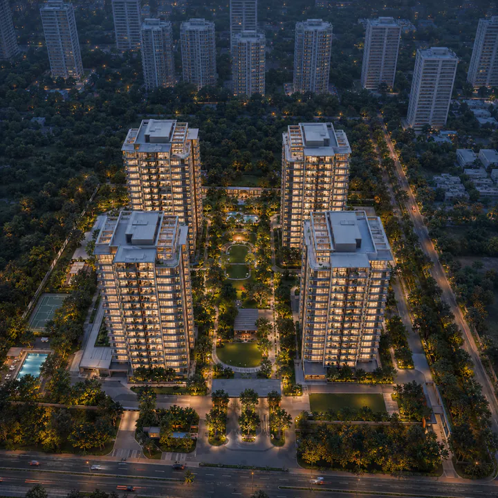
SNN Kannur Road Location — Kannuru Main Road, Bellahalli, North Bengaluru
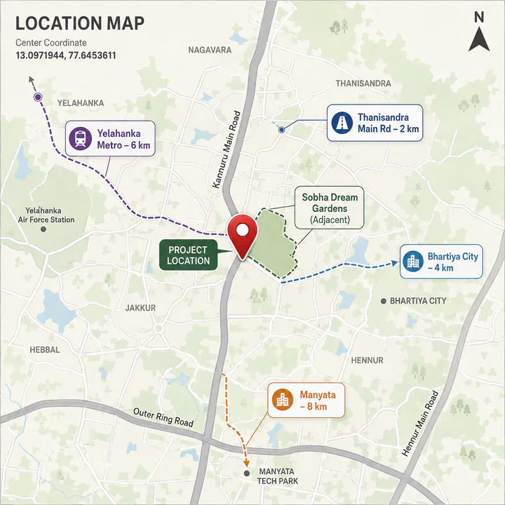
SNN Kannur Road sits on Kannuru Main Road at Mitganahalli, Bellahalli, off Thanisandra Main Road, in Yelahanka taluk, Bengaluru 560064 — immediately alongside Sobha Dream Gardens. The coordinates are 13.0971944, 77.6453611, Plus Code 3JWW+V4H. For location reading, SNN Raj Azaleas keeps the context local: commute anchors, school access, hospital reach, retail convenience, and last-mile movement decide whether the address works.
SNN Kannur Road on the map
 View on Google Maps →
Position within North Bengaluru matters more here than the zone label. This site is east of the Yelahanka satellite town, north of Hennur, and two kilometres east of the Thanisandra Main Road spine — which puts it inside the Manyata Tech Park catchment while pricing 15 to 20 per cent below Thanisandra proper and Hebbal.
Macro position — the Thanisandra corridor
Thanisandra Main Road is the artery that made this part of Bengaluru. It runs from Nagawara and the Outer Ring Road in the south, past Manyata Tech Park and Bhartiya City, north toward Jakkur and Yelahanka. Everything east of it — Bellahalli, Mitganahalli, Kannuru, Chikkagubbi — has filled in over the last decade as the Manyata workforce looked for housing it could afford within a reasonable commute.
The economic anchor is Manyata Tech Park at Nagawara: well over a lakh of workers across its campuses, the largest single employment cluster in North Bengaluru, and the demand floor under every rental in this belt. Around it sit Karle Town Centre SEZ, Kirloskar Business Park, Bhartiya Centre of Information Technology and the Bengaluru Signature Business Park — an employment mass concentrated within a ten-kilometre radius of this site.
North of that runs the second economy: the airport corridor along NH-44, with the Aerospace SEZ, the Hardware Technology Park and the Devanahalli business parks. It is further away from here than from the Yelahanka-side addresses, but it is reachable, and it means a two-income household is not tied to a single employment cluster.
Micro position — Kannuru Main Road
Kannuru Main Road is a short east–west road running off Thanisandra Main Road into the Bellahalli–Mitganahalli pocket. Five years ago it was a village road. It is now one of the more comprehensively de-risked residential addresses in North Bengaluru, and the reason is specific: Sobha built 1,780 homes on it.
That is the practical case for this address. The biggest risk in an emerging Bengaluru pocket is rarely the building — it is whether the approach road gets widened, whether BWSSB water actually arrives or the community runs on tankers, whether retail follows, and whether the last two kilometres are drivable in October. On Kannuru Main Road those questions were answered first by a large branded community that had to solve them to hand over. A buyer here is moving into infrastructure that exists rather than betting on infrastructure that is promised.
The honest counterweight: this is still a pocket in formation. Retail beyond the daily-needs level means a trip to Bhartiya City. Internal road quality off the main spine varies. And the arterial capacity of Thanisandra Main Road is finite and heavily used at peak.
Road connectivity
| Route | Distance | Note |
|---|---|---|
| Kannuru Main Road | On site | Direct frontage |
| Sobha Dream Gardens | Adjacent | The road's anchor community |
| Thanisandra Main Road | 2 km | The arterial south to Nagawara and the ORR, east to Hennur |
| Bellahalli Main Road | 2 km | The parallel northern route toward Kogilu |
| Hennur–Bagalur Road | 5 km | Alternative eastern arterial |
| Outer Ring Road (Hebbal / Nagawara) | 10 km | Connects east to KR Puram, west to Tumkur Road |
| NH-44 (Bellary Road) | 6 km | Elevated corridor to the airport |
Metro connectivity
The Blue Line is the forward infrastructure story for North Bengaluru as a whole, and its timeline is the main variable in any investment case here.
| Element | Detail |
|---|---|
| Line | Blue Line, Namma Metro |
| Alignment | Central Silk Board → Outer Ring Road → Kasturinagar → Nagawara → Hebbal → Yelahanka → KIAL Terminals |
| Nearest station | Yelahanka (Kogilu Cross) — at the NH-44 × Kogilu Road junction |
| Distance from site | ~6 km |
| Phase 2A | 13 stations, Silk Board to KR Puram — targeted late 2026, with depot connectivity a known risk that may push to 2027 |
| Phase 2B | 17 stations, the airport extension — targeted December 2027 |
Six kilometres is a drive or a feeder ride, not a walk, and it should be stated as such. The Nagawara terminus of the Pink Line, at roughly the same distance to the south, is the other rail asset within reach. The realistic near-term picture is that this remains a car-and-two-wheeler address with metro as a medium-term convenience rather than a daily-use station.
Rail and air
| Asset | Distance |
|---|---|
| Yelahanka Junction railway station | ~8 km |
| Bengaluru Cantonment | ~12 km |
| KSR Bengaluru City Junction | ~18 km |
| Kempegowda International Airport | ~22 km, ~35 min |
Tech parks and employment
| Employment cluster | Approximate distance |
|---|---|
| Manyata Tech Park, Nagawara | 8 km |
| Bhartiya Centre of Information Technology | 4 km |
| Karle Town Centre SEZ, Nagawara | 9 km |
| Kirloskar Business Park, Hebbal | 11 km |
| Embassy Manyata Business Park (adjacent campuses) | 8 km |
| Bengaluru Signature Business Park, Hebbal | 11 km |
| Aerospace SEZ, Devanahalli | 20 km |
| Hardware Technology Park, Devanahalli | 21 km |
Manyata at eight kilometres is the anchor — a 20–25 minute drive outside peak, longer at 9 a.m. Bhartiya Centre of Information Technology at four kilometres is the closest employment of any scale and an underrated one: it sits inside the Bhartiya City development along with the mall, which means a resident working there has a sub-fifteen-minute commute and a full retail ecosystem at the same address.
Schools
| School | Approximate distance |
|---|---|
| REVA University | 3 km |
| Legacy School, Yelahanka | 6 km |
| Vidyashilp Academy, Jakkur | 5 km |
| Canadian International School, Yelahanka | 7 km |
| Delhi Public School North, Sahakar Nagar | 9 km |
| Ryan International School, Yelahanka | 7 km |
| Sishu Griha, Hennur | 5 km |
| Presidency School, Nagawara | 8 km |
| VIBGYOR High, Hennur | 6 km |
| Stonehill International School, Tarahunise | 14 km |
Hospitals
| Hospital | Approximate distance |
|---|---|
| Aster CMI Hospital, Hebbal | 11 km |
| Columbia Asia Hospital, Hebbal | 11 km |
| Cytecare Cancer Hospital, Yelahanka | 8 km |
| Baptist Hospital, Bellary Road | 11 km |
| Regal Hospital, Yelahanka | 7 km |
| Manipal Hospital, Hebbal | 11 km |
| Motherhood Hospital, Hebbal | 11 km |
| Cratis Hospital, Hennur | 6 km |
Tertiary care sits at the Hebbal cluster, around eleven kilometres — a real distance and one worth weighing. Cytecare at Yelahanka and the Hennur hospitals cover the nearer band.
Retail, food and leisure
Bhartiya City at four kilometres is the defining retail asset for this address. It combines the Bhartiya Mall of Bengaluru — the largest mall in North Bengaluru — with offices, hotel and residential, which makes it a destination rather than a shopping trip. Elements Mall at Nagawara is around nine kilometres, Esteem Mall at Hebbal eleven, and RMZ Galleria at Yelahanka within a short drive.
Day-to-day retail runs along Thanisandra Main Road, which now carries the full complement of supermarkets, pharmacies, clinics, restaurants and gyms that a decade of residential absorption produces. The retail immediately serving Sobha Dream Gardens is the closest cluster.
For leisure, Jakkur Lake and Jakkur Aerodrome are about six kilometres, Hebbal Lake eleven, and Nandi Hills roughly an hour and a quarter north.
Honest trade-offs
Metro is a drive, not a walk. At roughly six kilometres to Yelahanka (Kogilu Cross), this is not a metro-adjacent address. Treat the Blue Line as a medium-term convenience and a valuation catalyst for the belt, not as a daily commute solution from the front gate.
Arterial dependence. All traffic from this pocket exits via Thanisandra Main Road, which congests between 8:30 and 10:30 a.m. and again in the evening. A Manyata run that takes 20–25 minutes off-peak is a 35–45 minute proposition at 9 a.m.
Tertiary healthcare is eleven kilometres away. The Hebbal hospital cluster is the nearest full-service option. For a household with an elderly member, that distance is a genuine consideration.
A flat twelve months. Bellahalli's apartment prices have moved roughly 0–0.4% year-on-year after appreciating 39.5% over ten years. The near-term return depends on delivery of infrastructure rather than on momentum already in the market.
The investment case
Three supports, in order of certainty:
- Manyata at eight kilometres. An established employment base of well over a lakh workers, not a speculative one. It is the floor under both rentals and resale in this belt.
- A proved-out address. Sobha's 1,780 homes on this road have already established road capacity, water, retail and a resale market. Very few emerging Bengaluru pockets offer that before you buy.
- A product the road does not have. Kannuru Main Road currently supplies 1 and 2 BHK stock only. Adding 3 and 4 BHK at moderate density serves the upgrade buyer who otherwise leaves the pocket — and upgrade demand is what pushes a micro-market's average ticket up over time.
Against that: entry is into a price plateau, the metro station is six kilometres away, and the developer is a credible mid-tier private company rather than a listed one. A five-to-seven-year hold, with diligence done properly at the point of registration.
SNN Kannur Road Location — frequently asked questions
Next step for SNN Kannur Road
SNN Kannur Road launches in Q3 2026. Pre-launch registrations receive the configuration and pricing sheet ahead of the public release, priority on floor and unit selection, and direct notification when the Karnataka RERA registration is published.